On our way to Trout Lake along the Columbia River we still had some patches of blue sky. But it changed to rain as we arrived at the trail head.
After slowly getting ready for the approach, carrying all the gear like tent, cooker, 2 days of food, overnight gear - the rain stopped and we had a great Saturday afternoon approach:
Snow did cover nearly the whole trail, only for the first mile or so some patches of bare soil interrupted the snow - though I suppose 2 weeks from now most of that will be gone.
The winter route was still possible - all the way along Sucksdorf Ridge up the 3700m high volcano.
We made a small detour via the 'newest' dome - last time Adams erupted it was via the 'South Butte' here we are on top of South Butte looking up to Lunch counter or overnight area. The whole upper ridge here marks the start of lunch counter - a reasonable flat area with many sheltered overnight spots in between the rocks.
Just above South Butte we really started to feel the altitude - the missing oxygen made us go slower. We first had one longer coffee break before going all the way step by step to lunch counter. On top of that the wind did pick up considerably surpassing 25mph regularly I would say a strong 6 Beaufort.
It was on a gentle slope - but the length and elevation, especially carrying all the overnight gear - and not being used to high altitude made us go slow.
Finally our overnight spot at the start of lunch counter with nice views south - oxygen level at this altitude is 73% of that at sea level. Thus 27% less oxygen to breath and scramble up or down.
Even cooking we realized that the Whisperlite may not have been ideal for this altitude - next time I'll take my XKG. I had Couscous and afterwards even noodles for dinner and was totally full afterwards.
The shadow of the volcano started growing to the east, spreading through Yakima Valley.
It grew very large just before sunset.
This is the view south and down onto South Butte.
Evening Clouds!
We even could see Pikers Peak - the false summit of Mt Adams. On our route for the next day.
Evening panorama was great - little clouds great views. Since the forecast was windy, but kind of good we hoped for the best and were looking forward for tomorrow.
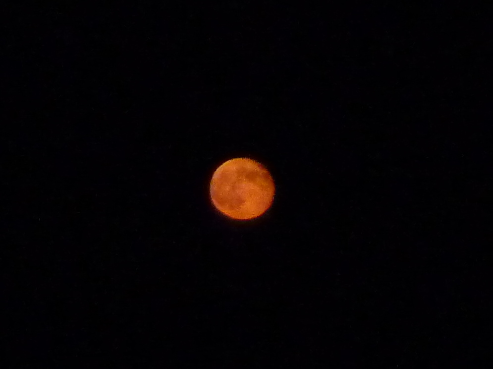
Just after sunset we had a beautiful moon rise - sometimes timing is just right! Just a few minutes after the sun disappeared in the west, an orange flash in the east irritated us - seconds later we realized it is the moon. A few minutes later he was up and round, orange in the sky.


The next morning greeted us with rain, strong hail - but luckily less wind. Night temperatures stayed around freezing, but luckily the tent in a sheltered position stayed warm, inside temperatures at 6°C (~44°F). We started climbing late due to the weather and left camp at 6:30 in cloudy conditions, views about 30-50ft. This did deteriorate significantly on the way up, 3/4 of the way up to the false summit, or half way to the real summit we did cancel our approach. For the last 2 hours views had been less than 15ft (5m) - sometimes below 10ft (3m). And by the looks of it, despite gaining elevation, it did not get better higher up. At this altitude oxygen is down to 69% of sea level, though I did not feel the low oxygen on the second day - only day 1 with a heavy pack I did feel it for sure! We did a careful glissade/walk down, following our tracks back onto lunch counter. Glissading in walking speed, to be able to stop within 2 meters - latest!
It probably was a good call - since talking to others it was not better on top and we would have had to rely even more on GPS and altimeter than we already did - and since we only had one altimeter and one GPS with us - the risk of one failing was not worth it.
Even looking back shows the whole of Mt Adams above Lunch Counter in the clouds - we would not have been able to see anything, since the clouds were thick and higher than 12.000ft.
We got some nice views of the Columbia River again and were back in Seattle by 9pm.
Here is the elevation profile and temperature over time - the high temperatures close to our 'personal' summit are due to the fact that I put mittens above my hands including the altimeter I was wearing around my wrist. Overall elevation gain was just a bit more than 1500m.
Overall a great weekend - and I so want to do such high mountains again - this low oxygen is interesting and tempting!!!